
 8.2K
8.2K 


With kilometres of underground tunnels and a few bridges crisscrossing the Downtown core, Toronto's pedestrian PATH system helps us move about the city without having to contend with vehicles or inclement weather. As new development comes to Toronto, our City Planning department looks for new linkages in the network: our sidewalks aren't getting much wider, so new pedestrian infrastructure needs to be accommodated within the new buildings. In the image below, the existing PATH network's tunnels and bridges are marked by solid orange lines, while dotted lines approximate planned and under construction expansions.
The network currently spans much of the city core, but as new development continues to spring up south of the rail corridor, the possibility for an expansion as far south as Queens Quay has come about. Under construction now is an above ground passageway which will connect the Air Canada Centre—the network's current southernmost connection—with the adjacent district's latest high-rise development projects.
You'll see the Air Canada Centre near the bottom of the map above. From it a dotted orange line leads south towards Queens Quay, showing the route of the walkway which will pass underneath the Gardiner Expressway but above Lake Shore Boulevard, connecting first through the Harbour Plaza complex and then on to the WaterPark Place complex, both currently being built or expanded.
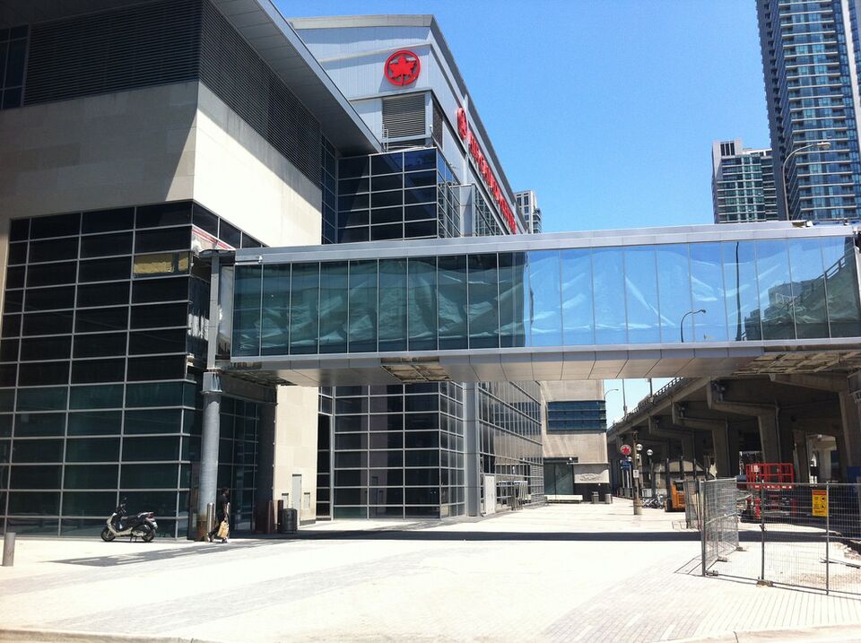
The first portion of bridge was recently attached to the south side of the Air Canada Centre which runs just to the north side of The Gardiner. Next up will be a section of bridge which passes below the elevated road. That piece will be a special one in that it will be able to slide laterally, allowing access to any part of the underside of the highway whenever repairs to it are required.
After crossing underneath the Gardiner Expressway, the bridge will pass through a multi-use complex which will be home to both the Sun Life Financial Tower and the two-tower Harbour Plaza Residences. The complex, currently under construction, is omitted in the south-facing rendering above, but shown in the northwest facing rendering below. The PATH extension through the Menkes-built complex will open before the rest of the complex does itself, with the walkway protected during the construction process.
The new PATH link will then cross above Harbour Street and the Yonge offramp from the Gardiner Expressway. (That offramp will be replaced in a few years time by a new ramp at Simcoe Street). The PATH bridge will then enter Oxford Properties' WaterPark Place complex, where the soon-to-open RBC WaterPark Place III office tower is now under construction.
We will be sure to return with further updates as construction of this pedestrian infrastructure improvement progresses. In the meantime, if you want to know more about the PATH network expansions or the developments in this area, more information and plenty of renderings can be found in our dataBase files, linked below. Want to talk about it? You can join in on the conversations in the associated Forum threads, or leave a comment in the space provided on this page.


